Celebration of Scholars
Integrating Remote Sensing into Higher Level Geoscience Education using Unmanned Aerial Systems
 Name:
Kathleen Cochran
Name:
Kathleen Cochran
Major: Geoscience; Geographic Information Science
Hometown: Rochester, IL
Faculty Sponsor: Matthew Zorn
Other Sponsors:
Type of research: Independent research
Funding: Wisconsin Space Grant Consortium
 Name:
Calvert McCormick
Name:
Calvert McCormick
Major: Geographic Information Science, Geoscience and History
Hometown: Newburyport, MA
Faculty Sponsor: Matthew Zorn
Other Sponsors:
Type of research: Independent research
Funding: Wisconsin Space Grant Consortium
 Name:
Conner Plagge
Name:
Conner Plagge
Major: GIS and Geoscience
Hometown: Aitkin, MN
Faculty Sponsor: Matthew Zorn
Other Sponsors:
Type of research: Independent research
Funding: Wisconsin Space Grant Consortium
Abstract
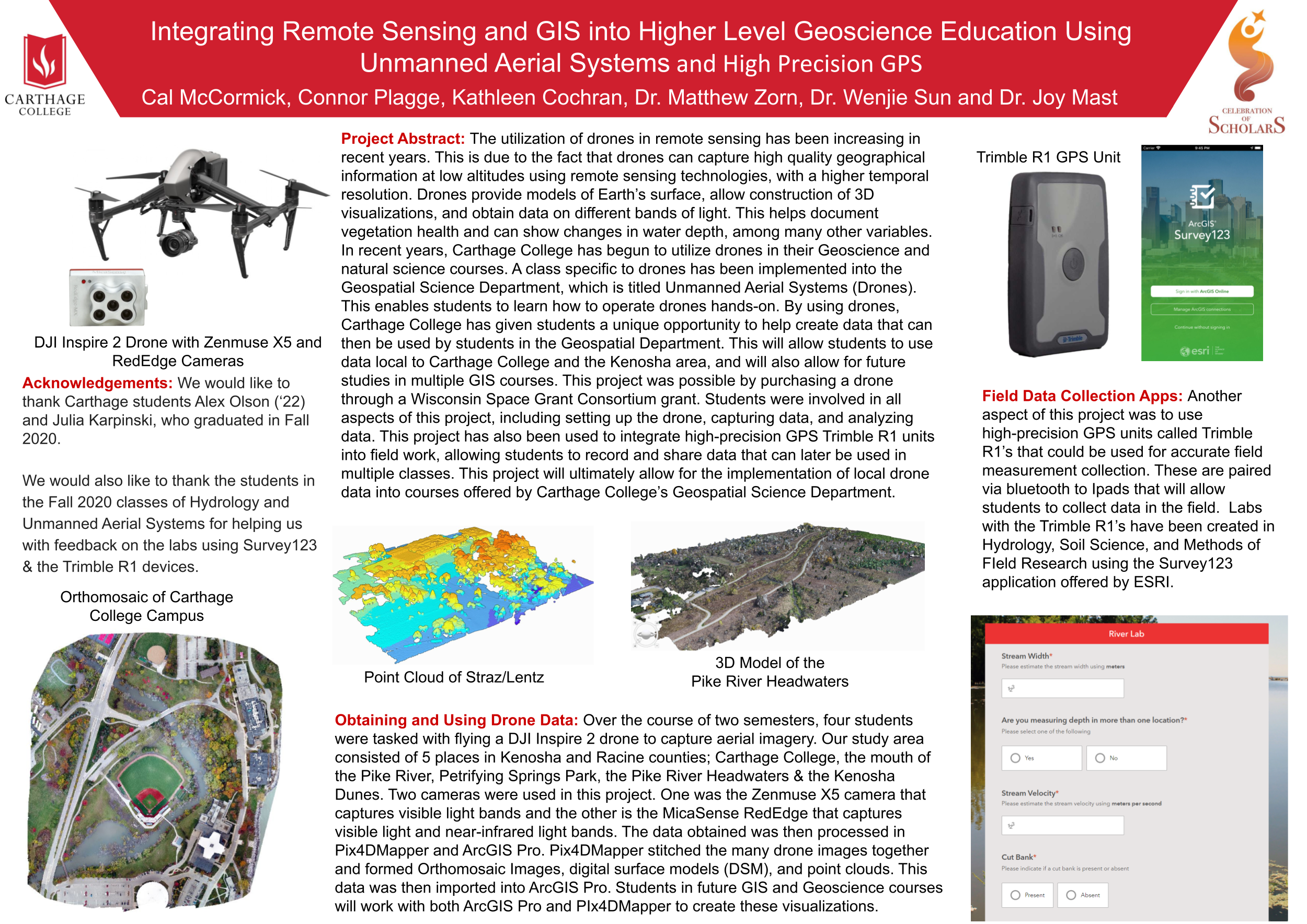
The utilization of drones in remote sensing has been increasing in recent years. This is due to the fact that drones can capture high-quality geographical information at low altitudes using remote sensing technologies with a higher temporal resolution. Drones provide temperature data, allow the construction of 3-D visualizations, and obtain data on different bands of light. This helps document vegetation health and can show changes in water depth, among many other variables. In recent years, Carthage College has begun to utilize drones in their Geoscience and natural science courses. A class-specific to drones has been implemented into the Geospatial Science Department, titled Unmanned Aerial Systems (Drones). This enables students to learn how to operate drones hands-on. By using drones, students can create data for use in the department. This will allow students to use data local to Carthage College and enable future studies in multiple GIS courses. This was possible by purchasing a drone through a Wisconsin Space Grant Consortium grant. Students were involved in all aspects of this project, including setting up the drone, capturing data, and analyzing data. This project has also been used to integrate high-precision GPS Trimble R1 units into fieldwork, enabling students to record and share data that can later be used in multiple classes. This project will ultimately allow for implementing local drone data into courses offered by Carthage College’s Geospatial Department.
Submit date: Feb. 25, 2021, 6:59 p.m.